IMAGES TAKEN NEAR TO
Pye Bridge End, MILTON KEYNES, MK10 9QZ
Introduction
This page details the photographs taken nearby to Pye Bridge End, MK10 9QZ by members of the Geograph project.
The Geograph project started in 2005 with the aim of publishing, organising and preserving representative images for every square kilometre of Great Britain, Ireland and the Isle of Man.

There are currently over 7.5m images from over14,400 individuals and you can help contribute to the project by visiting https://www.geograph.org.uk
Image Map
Images are licensed for reuse under creativecommons.org/licenses/by-sa/2.0
Notes
- Clicking on the map will re-center to the selected point.
- The higher the marker number, the further away the image location is from the centre of the postcode.
Image Listing (10 Images Found)
Images are licensed for reuse under creativecommons.org/licenses/by-sa/2.0
Image
Details
Distance
1
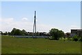
Broughton
At wet day at a disused pit.
Image: © Burgess Von Thunen
Taken: 27 Nov 2012
0.07 miles

4
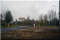
Milton Keynes : Dalton Gate
Looking along Dalton Gate in Milton Keynes.
Image: © Lewis Clarke
Taken: 24 Mar 2018
0.19 miles
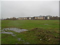
5
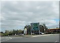
View from Fox Milne roundabout to garage
Image: © John Firth
Taken: 22 Sep 2013
0.19 miles
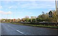
6
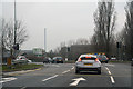
Milton Keynes : Tongwell Street A4146
Approaching the Fox Milne Roundabout.
Image: © Lewis Clarke
Taken: 24 Mar 2018
0.20 miles

8
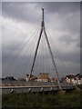
Bridge in Broughton
New road bridge near the Hungry Horse Pub in Broughton
Image: © Mr Biz
Taken: 22 Jul 2006
0.21 miles