IMAGES TAKEN NEAR TO
Ladymeadow Court, MILTON KEYNES, MK10 9HZ
Introduction
This page details the photographs taken nearby to Ladymeadow Court, MK10 9HZ by members of the Geograph project.
The Geograph project started in 2005 with the aim of publishing, organising and preserving representative images for every square kilometre of Great Britain, Ireland and the Isle of Man.

There are currently over 7.5m images from over14,400 individuals and you can help contribute to the project by visiting https://www.geograph.org.uk
Image Map
Images are licensed for reuse under creativecommons.org/licenses/by-sa/2.0
Notes
- Clicking on the map will re-center to the selected point.
- The higher the marker number, the further away the image location is from the centre of the postcode.
Image Listing (4 Images Found)
Images are licensed for reuse under creativecommons.org/licenses/by-sa/2.0
Image
Details
Distance
2
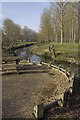
River Ouzel, Milton Keynes
Small picnic area next to the river just south of the Childs Way bridge.
Image: © Paul Harrop
Taken: 25 Mar 2012
0.20 miles
3
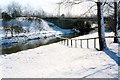
River ouzel goes under Childs Way by Willen Lake
Image: © Philip Jeffrey
Taken: 27 Feb 1995
0.25 miles
4

Milton Keynes Village
Milton Keynes Village Green.
Milton Keynes Village gave its name to the City of Milton Keynes.
Image: © Peter Roberts
Taken: 25 Mar 2005
0.25 miles