IMAGES TAKEN NEAR TO
Noon Layer Drive, MILTON KEYNES, MK10 9EN
Introduction
This page details the photographs taken nearby to Noon Layer Drive, MK10 9EN by members of the Geograph project.
The Geograph project started in 2005 with the aim of publishing, organising and preserving representative images for every square kilometre of Great Britain, Ireland and the Isle of Man.

There are currently over 7.5m images from over14,400 individuals and you can help contribute to the project by visiting https://www.geograph.org.uk
Image Map
Images are licensed for reuse under creativecommons.org/licenses/by-sa/2.0
Notes
- Clicking on the map will re-center to the selected point.
- The higher the marker number, the further away the image location is from the centre of the postcode.
Image Listing (11 Images Found)
Images are licensed for reuse under creativecommons.org/licenses/by-sa/2.0
Image
Details
Distance
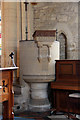
2

All Saints, Milton Keynes village - Font
Image: © John Salmon
Taken: 10 Sep 2016
0.24 miles

4
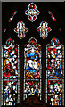
All Saints, Milton Keynes village - Stained glass window
Image: © John Salmon
Taken: 10 Sep 2016
0.25 miles
5
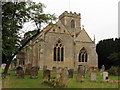
Milton Keynes village, All Saints church
Image: © Dave Kelly
Taken: 11 Aug 2015
0.25 miles
6
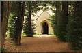
All Saints, Milton Keynes village - Porch
Image: © John Salmon
Taken: 10 Sep 2016
0.25 miles
7
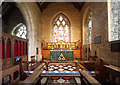
All Saints, Milton Keynes village - Chancel
Image: © John Salmon
Taken: 10 Sep 2016
0.25 miles
8
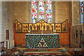
All Saints, Milton Keynes village - Sanctuary
Image: © John Salmon
Taken: 10 Sep 2016
0.25 miles
9
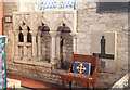
All Saints, Milton Keynes village - Piscina & sedilia
Image: © John Salmon
Taken: 10 Sep 2016
0.25 miles
10
All Saints, Milton Keynes village - Pulpit
Image: © John Salmon
Taken: 10 Sep 2016
0.25 miles