IMAGES TAKEN NEAR TO
Luke Place, MILTON KEYNES, MK10 9BS
Introduction
This page details the photographs taken nearby to Luke Place, MK10 9BS by members of the Geograph project.
The Geograph project started in 2005 with the aim of publishing, organising and preserving representative images for every square kilometre of Great Britain, Ireland and the Isle of Man.

There are currently over 7.5m images from over14,400 individuals and you can help contribute to the project by visiting https://www.geograph.org.uk
Image Map
Images are licensed for reuse under creativecommons.org/licenses/by-sa/2.0
Notes
- Clicking on the map will re-center to the selected point.
- The higher the marker number, the further away the image location is from the centre of the postcode.
Image Listing (38 Images Found)
Images are licensed for reuse under creativecommons.org/licenses/by-sa/2.0
Image
Details
Distance
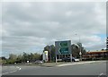
2
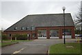
Broughton fire station
Broughton fire station, H6 Childs Way, Broughton, Buckinghamshire
Image: © Kevin Hale
Taken: 24 Nov 2007
0.07 miles
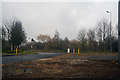
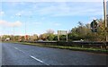
3
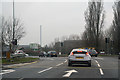
Milton Keynes : Tongwell Street A4146
Approaching the Fox Milne Roundabout.
Image: © Lewis Clarke
Taken: 24 Mar 2018
0.10 miles
4
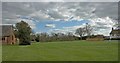
Milton Keynes Village
Milton Keynes Village Green.
Milton Keynes Village gave its name to the City of Milton Keynes.
Image: © Peter Roberts
Taken: 25 Mar 2005
0.13 miles
5
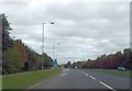
Start of bus lane in Childs Way
West of Fox Milne roundabout
Image: © John Firth
Taken: 22 Sep 2013
0.14 miles
6
Milton Keynes : Dalton Gate
Looking along Dalton Gate in Milton Keynes.
Image: © Lewis Clarke
Taken: 24 Mar 2018
0.14 miles
7
View from Fox Milne roundabout to garage
Image: © John Firth
Taken: 22 Sep 2013
0.14 miles
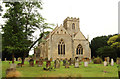
9
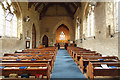
All Saints, Milton Keynes village - East end
Image: © John Salmon
Taken: 10 Sep 2016
0.19 miles