IMAGES TAKEN NEAR TO
Hopkins Close, MILTON KEYNES, MK10 9AS
Introduction
This page details the photographs taken nearby to Hopkins Close, MK10 9AS by members of the Geograph project.
The Geograph project started in 2005 with the aim of publishing, organising and preserving representative images for every square kilometre of Great Britain, Ireland and the Isle of Man.

There are currently over 7.5m images from over14,400 individuals and you can help contribute to the project by visiting https://www.geograph.org.uk
Image Map
Images are licensed for reuse under creativecommons.org/licenses/by-sa/2.0
Notes
- Clicking on the map will re-center to the selected point.
- The higher the marker number, the further away the image location is from the centre of the postcode.
Image Listing (27 Images Found)
Images are licensed for reuse under creativecommons.org/licenses/by-sa/2.0
Image
Details
Distance
1
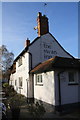
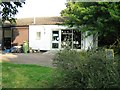
The Swan Inn
There are probably the remains of an Ordnance Survey cut mark benchmark, described on the Bench Mark Database at http://www.bench-marks.org.uk/bm80615 , on the near corner, left hand face, of the main part of the pub building
Image: © Roger Templeman
Taken: 23 Nov 2016
0.10 miles
3
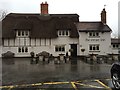
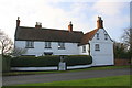
A corner of old Milton Keynes
Like most visitors to Milton Keynes I soon got lost and finally ended up in what was the original village, which still contains some of the original 17th century buildings, including thatched cottages.
Image: © John Winfield
Taken: 1 Jul 2006
0.11 miles
5
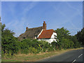
Manor Farmhouse, Milton Keynes Village
There is an OS benchmark Image on the front of the house at its right hand corner, just above a black skirt at the junction with the abutting brick wall
Image: © Roger Templeman
Taken: 23 Nov 2016
0.18 miles
6
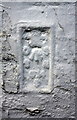
Overpainted benchmark on Milton Keynes Village Manor Farmhouse
Ordnance Survey flush bracket (serial identifier S074) benchmark described on the Bench Mark Database at http://www.bench-marks.org.uk/bm782
Image: © Roger Templeman
Taken: 23 Nov 2016
0.18 miles
7
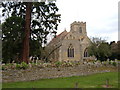
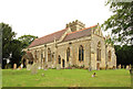
All Saints church, Milton Keynes Village
The church in the village that gives the town its name. The church is located on the old willen road.
Image: © Mr Biz
Taken: 18 Mar 2008
0.22 miles
8
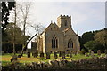
All Saints' Church
The tower centre and the flagstaff are components of an OS intersected station trig point, http://trigpointing.uk/trig/20022
Image: © Roger Templeman
Taken: 23 Nov 2016
0.23 miles
9
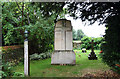
All Saints, Milton Keynes village - War Memorial
Image: © John Salmon
Taken: 10 Sep 2016
0.24 miles