IMAGES TAKEN NEAR TO
Artemis Grove, MILTON KEYNES, MK10 7LR
Introduction
This page details the photographs taken nearby to Artemis Grove, MK10 7LR by members of the Geograph project.
The Geograph project started in 2005 with the aim of publishing, organising and preserving representative images for every square kilometre of Great Britain, Ireland and the Isle of Man.

There are currently over 7.5m images from over14,400 individuals and you can help contribute to the project by visiting https://www.geograph.org.uk
Image Map
Images are licensed for reuse under creativecommons.org/licenses/by-sa/2.0
Notes
- Clicking on the map will re-center to the selected point.
- The higher the marker number, the further away the image location is from the centre of the postcode.
Image Listing (8 Images Found)
Images are licensed for reuse under creativecommons.org/licenses/by-sa/2.0
Image
Details
Distance
1
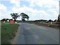
Minor road towards Salford
Heading east.
A lot of new construction around here.
Image: © JThomas
Taken: 22 Aug 2015
0.11 miles
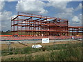
2
New houses under construction on Broughton Road, Milton Keynes
The area is expanding into this field in the last year.
Image: © David Howard
Taken: 9 Oct 2022
0.17 miles
4
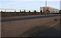
Broughton Road, Milton Keynes
The field appears ready for more housing. Looking towards Walton High School.
Image: © David Howard
Taken: 9 Oct 2022
0.19 miles
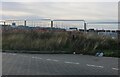
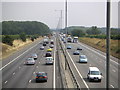
5

Borough of Milton Keynes : M1 Motorway
The M1 Motorway between Junction 13 (Ridgmont) and Junction 14 (Broughton).
Image: © Lewis Clarke
Taken: 5 Oct 2018
0.21 miles
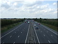
6
The M1
Another view of the M1 from a bridge on the road joining Newport Road and Salford. This view was looking southbound.
Image: © Mr Biz
Taken: 26 Jul 2006
0.22 miles
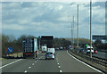
7
M1 northbound near Milton Keynes
From an over bridge.
Image: © JThomas
Taken: 22 Aug 2015
0.24 miles
8
Roadworks on the M1 near Milton Keynes
Heading south east towards London.
Image: © JThomas
Taken: 5 Mar 2012
0.25 miles