IMAGES TAKEN NEAR TO
Andania Lane, MILTON KEYNES, MK10 7JZ
Introduction
This page details the photographs taken nearby to Andania Lane, MK10 7JZ by members of the Geograph project.
The Geograph project started in 2005 with the aim of publishing, organising and preserving representative images for every square kilometre of Great Britain, Ireland and the Isle of Man.

There are currently over 7.5m images from over14,400 individuals and you can help contribute to the project by visiting https://www.geograph.org.uk
Image Map
Images are licensed for reuse under creativecommons.org/licenses/by-sa/2.0
Notes
- Clicking on the map will re-center to the selected point.
- The higher the marker number, the further away the image location is from the centre of the postcode.
Image Listing (5 Images Found)
Images are licensed for reuse under creativecommons.org/licenses/by-sa/2.0
Image
Details
Distance
2
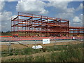
Broughton Road, Milton Keynes
The field appears ready for more housing. Looking towards Walton High School.
Image: © David Howard
Taken: 9 Oct 2022
0.07 miles
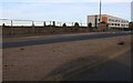
3
New houses on Broughton Road, Milton Keynes
They are almost finished. They look quite nice but could do with front gardens, this was a field after all.
Image: © David Howard
Taken: 9 Oct 2022
0.17 miles
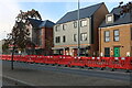
4
Minor road towards Salford
Heading east.
A lot of new construction around here.
Image: © JThomas
Taken: 22 Aug 2015
0.22 miles
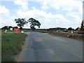
5
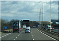
Roadworks on the M1 near Milton Keynes
Heading south east towards London.
Image: © JThomas
Taken: 5 Mar 2012
0.25 miles