IMAGES TAKEN NEAR TO
Bow Road, MILTON KEYNES, MK10 7GN
Introduction
This page details the photographs taken nearby to Bow Road, MK10 7GN by members of the Geograph project.
The Geograph project started in 2005 with the aim of publishing, organising and preserving representative images for every square kilometre of Great Britain, Ireland and the Isle of Man.

There are currently over 7.5m images from over14,400 individuals and you can help contribute to the project by visiting https://www.geograph.org.uk
Image Map
Images are licensed for reuse under creativecommons.org/licenses/by-sa/2.0
Notes
- Clicking on the map will re-center to the selected point.
- The higher the marker number, the further away the image location is from the centre of the postcode.
Image Listing (22 Images Found)
Images are licensed for reuse under creativecommons.org/licenses/by-sa/2.0
Image
Details
Distance
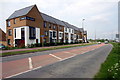
1
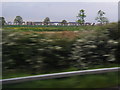
View west from M1 northbound near New Covert with new housing beyond
Image: © Colin Pyle
Taken: 18 May 2012
0.12 miles
2
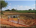
New culvert adjacent to building site in the Broughton area of Milton Keynes
Image: © Andrew Tatlow
Taken: 1 Jun 2009
0.14 miles
3
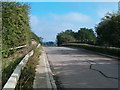
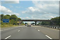
Broughton Grounds Lane
Broughton Grounds Lane as it passes over the M1.
Image: © Richard Schmidt
Taken: 23 Sep 2006
0.16 miles
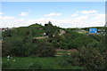
4
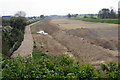
The beginnings of building work by the M1
Image: © Philip Jeffrey
Taken: 18 May 2012
0.17 miles
5
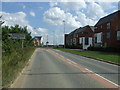
Newport Road (A5130), Broughton
Looking south east.
Image: © JThomas
Taken: 22 Aug 2015
0.18 miles
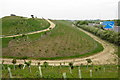
7
Landscaping for Brooklands Meadow Park
More mature shrubbery than in Image
Image: © Philip Jeffrey
Taken: 15 May 2016
0.19 miles
8
New landscaping for Brooklands Meadow Park
Image: © Philip Jeffrey
Taken: 18 May 2012
0.19 miles
10
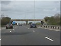
Broughton Farm accommodation bridge, M1 motorway
Image: © Peter Whatley
Taken: 3 Apr 2012
0.20 miles