IMAGES TAKEN NEAR TO
Launceston Drive, MILTON KEYNES, MK10 7BS
Introduction
This page details the photographs taken nearby to Launceston Drive, MK10 7BS by members of the Geograph project.
The Geograph project started in 2005 with the aim of publishing, organising and preserving representative images for every square kilometre of Great Britain, Ireland and the Isle of Man.

There are currently over 7.5m images from over14,400 individuals and you can help contribute to the project by visiting https://www.geograph.org.uk
Image Map
Images are licensed for reuse under creativecommons.org/licenses/by-sa/2.0
Notes
- Clicking on the map will re-center to the selected point.
- The higher the marker number, the further away the image location is from the centre of the postcode.
Image Listing (7 Images Found)
Images are licensed for reuse under creativecommons.org/licenses/by-sa/2.0
Image
Details
Distance
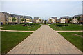
2
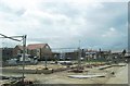
Broughton Gate
The Broughton area of Milton Keynes has a lot of new residential property in various states of construction; one wondered just how much of a helping hand the buyer might receive!
Image: © Andrew Tatlow
Taken: 4 May 2009
0.16 miles
3
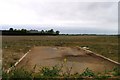
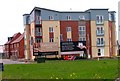
Road to nowhere
Sometime this will be houses!
Image: © Andrew Tatlow
Taken: 4 May 2009
0.17 miles
4

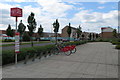
Bikes in Bodmin Place
Looks like electric scooters are the preferred mode of transport these days
Image: © Philip Jeffrey
Taken: 6 Aug 2022
0.18 miles
5
Bike sharing station by Warwick Avenue
Image: © Philip Jeffrey
Taken: 5 Jul 2016
0.19 miles
7
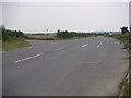
Newport Road Junction
The Junction off the Newport Road to Salford. Due to the frequent lorries turning across traffic towards the landfill site, a slip lane has been installed to help keep traffic flowing.
Image: © Mr Biz
Taken: 26 Jul 2006
0.23 miles