IMAGES TAKEN NEAR TO
Churston, MILTON KEYNES, MK10 7BJ
Introduction
This page details the photographs taken nearby to Churston, MK10 7BJ by members of the Geograph project.
The Geograph project started in 2005 with the aim of publishing, organising and preserving representative images for every square kilometre of Great Britain, Ireland and the Isle of Man.

There are currently over 7.5m images from over14,400 individuals and you can help contribute to the project by visiting https://www.geograph.org.uk
Image Map
Images are licensed for reuse under creativecommons.org/licenses/by-sa/2.0
Notes
- Clicking on the map will re-center to the selected point.
- The higher the marker number, the further away the image location is from the centre of the postcode.
Image Listing (12 Images Found)
Images are licensed for reuse under creativecommons.org/licenses/by-sa/2.0
Image
Details
Distance
1
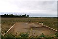
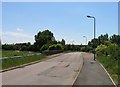
Road to nowhere
Sometime this will be houses!
Image: © Andrew Tatlow
Taken: 4 May 2009
0.11 miles
3
New housing on Newport Road (A5130), Broughton
Image: © JThomas
Taken: 22 Aug 2015
0.19 miles
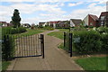
4
Broughton Road towards the old village
The paint is almost wet on these new buildings which were still not shown on any of the OS maps several months after the picture was taken.Kingswear Drive is to the left and not shown on the maps although it has a postcode!
Image: © Andrew Tatlow
Taken: 1 Jun 2009
0.20 miles
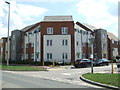
6
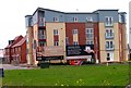
Broughton Gate
The Broughton area of Milton Keynes has a lot of new residential property in various states of construction; one wondered just how much of a helping hand the buyer might receive!
Image: © Andrew Tatlow
Taken: 4 May 2009
0.21 miles
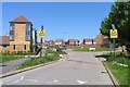
7
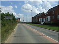
Newport Road (A5130), Broughton
Looking south east.
Image: © JThomas
Taken: 22 Aug 2015
0.22 miles
8
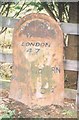
Old Milepost by the A5130 in Broughton, Milton Keynes
Pressed steel post by the former A5130, in parish of Broughton (Milton Keynes District), Newport Road. Outside Broughton Manor, opposite Broughton Grounds Lane, on grass verge back to a wooden fence and trees, on South side of road. Bucks pressing, erected by the County Council in the 20th century.
Area has been redeveloped so the milepost now stands behind a cycle track.
Inscription reads:-
: NEWPORT / PAGNELL / 3 : : BROUGHTON / PARISH / LONDON / 47 : : WOBURN / 5½ :
Milestone Society National ID: BU_NPWO03
Image: © A Rosevear
Taken: 17 Jan 2004
0.22 miles
10
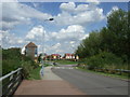
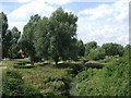
Broughton Road bridge
Broughton Road crosses a tributary of the River Ouse or Livet.
Image: © Andrew Tatlow
Taken: 1 Jun 2009
0.24 miles