IMAGES TAKEN NEAR TO
Standing Way, MILTON KEYNES, MK10 0AA
Introduction
This page details the photographs taken nearby to Standing Way, MK10 0AA by members of the Geograph project.
The Geograph project started in 2005 with the aim of publishing, organising and preserving representative images for every square kilometre of Great Britain, Ireland and the Isle of Man.

There are currently over 7.5m images from over14,400 individuals and you can help contribute to the project by visiting https://www.geograph.org.uk
Image Map
Images are licensed for reuse under creativecommons.org/licenses/by-sa/2.0
Notes
- Clicking on the map will re-center to the selected point.
- The higher the marker number, the further away the image location is from the centre of the postcode.
Image Listing (13 Images Found)
Images are licensed for reuse under creativecommons.org/licenses/by-sa/2.0
Image
Details
Distance
1
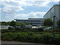
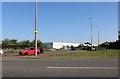
Warehouse in Brinklow, Milton Keynes
An industrial area of Milton Keynes populated by warehouses.
Image: © Cameraman
Taken: 16 Jun 2010
0.05 miles
2
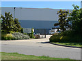
Waitrose Distribution Hub
Off Standing Way.
Image: © JThomas
Taken: 22 Aug 2015
0.07 miles
3
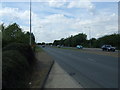
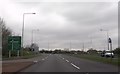
Standing Way (A421)
Heading west.
Road not shown on my old map.
Image: © JThomas
Taken: 22 Aug 2015
0.12 miles
4
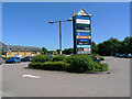
Car Park at Kingston District Centre, Milton Keynes
Image: © Cameraman
Taken: 16 Jun 2010
0.18 miles
5
Roundabout on Standing Way, Milton Keynes
Image: © David Howard
Taken: 29 Jun 2019
0.21 miles
6
Approaching Brinklow roundabout
Standing Way heading west
Image: © John Firth
Taken: 5 Apr 2014
0.21 miles
7
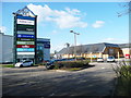
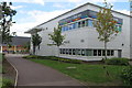
Kingston District Centre, Milton Keynes
The building behind the tower is the library.
Image: © Humphrey Bolton
Taken: 19 Mar 2018
0.21 miles
8
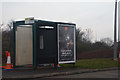
Milton Keynes : Bus Stop
A bus stop at Brinklow Roundabout South.
Image: © Lewis Clarke
Taken: 24 Mar 2018
0.23 miles
9
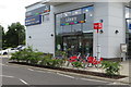
Kingston Library
With Santander Cycles MK sharing station in front
Image: © Philip Jeffrey
Taken: 5 Jul 2016
0.23 miles