IMAGES TAKEN NEAR TO
Yelsted Road, SITTINGBOURNE, ME9 7XG
Introduction
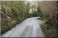
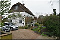
This page details the photographs taken nearby to Yelsted Road, ME9 7XG by members of the Geograph project.
The Geograph project started in 2005 with the aim of publishing, organising and preserving representative images for every square kilometre of Great Britain, Ireland and the Isle of Man.

There are currently over 7.5m images from over14,400 individuals and you can help contribute to the project by visiting https://www.geograph.org.uk
Image Map
Images are licensed for reuse under creativecommons.org/licenses/by-sa/2.0
Notes
- Clicking on the map will re-center to the selected point.
- The higher the marker number, the further away the image location is from the centre of the postcode.
Image Listing (20 Images Found)
Images are licensed for reuse under creativecommons.org/licenses/by-sa/2.0
Image
Details
Distance
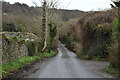
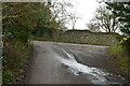
2
Junction at foot of Queendown Warren
The lane on the right runs along the foot of the bank, that on the left goes diagonally up it.
Image: © Robin Webster
Taken: 11 Jun 2016
0.14 miles
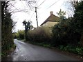
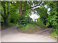
3
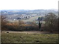
View from Queendown Warren
Looking south(ish) towards Yelsted. Queendown Warren is a steep escarpment maintained as a nature reserve. Most of this view is within the same grid square.
Image: © Penny Mayes
Taken: 15 Mar 2006
0.15 miles