IMAGES TAKEN NEAR TO
Rumstead Lane, SITTINGBOURNE, ME9 7RU
Introduction
This page details the photographs taken nearby to Rumstead Lane, ME9 7RU by members of the Geograph project.
The Geograph project started in 2005 with the aim of publishing, organising and preserving representative images for every square kilometre of Great Britain, Ireland and the Isle of Man.

There are currently over 7.5m images from over14,400 individuals and you can help contribute to the project by visiting https://www.geograph.org.uk
Image Map
Images are licensed for reuse under creativecommons.org/licenses/by-sa/2.0
Notes
- Clicking on the map will re-center to the selected point.
- The higher the marker number, the further away the image location is from the centre of the postcode.
Image Listing (19 Images Found)
Images are licensed for reuse under creativecommons.org/licenses/by-sa/2.0
Image
Details
Distance
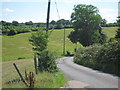
3
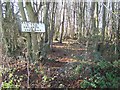
No Entry into Squirrel Wood
Taken from Rumstead Road near Appsfield Cottage.
As seen in photo, there are unofficial footpaths through the wood, but risk shotgun or worse injuries.
Image: © David Anstiss
Taken: 9 Dec 2008
0.06 miles
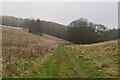
4
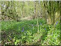
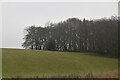
Bluebells in Squirrel Wood
Squirrel Wood covers about 1 square kilometre and runs down to the A249 in the next square to the north.
Image: © Penny Mayes
Taken: 22 Apr 2005
0.08 miles
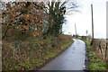
5
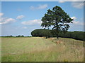
Field off Rumstead Lane
Near to Appsfield Farm.
Image: © Oast House Archive
Taken: 24 Jul 2011
0.08 miles