IMAGES TAKEN NEAR TO
Pett Road, SITTINGBOURNE, ME9 7RP
Introduction
This page details the photographs taken nearby to Pett Road, ME9 7RP by members of the Geograph project.
The Geograph project started in 2005 with the aim of publishing, organising and preserving representative images for every square kilometre of Great Britain, Ireland and the Isle of Man.

There are currently over 7.5m images from over14,400 individuals and you can help contribute to the project by visiting https://www.geograph.org.uk
Image Map
Images are licensed for reuse under creativecommons.org/licenses/by-sa/2.0
Notes
- Clicking on the map will re-center to the selected point.
- The higher the marker number, the further away the image location is from the centre of the postcode.
Image Listing (7 Images Found)
Images are licensed for reuse under creativecommons.org/licenses/by-sa/2.0
Image
Details
Distance
1
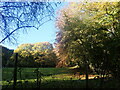
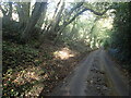
Looking towards Gore Wood
This view is from Pett Road, opposite Magpie Hall.
Image: © Marathon
Taken: 11 Nov 2023
0.05 miles
2
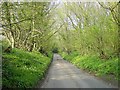
Hazel Street Road
Running down towards Little Pett.
Image: © Penny Mayes
Taken: 22 Apr 2005
0.08 miles
5
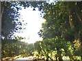
Pett Road
The woodland strip either side of Pett Road is quite narrow here before Gore Wood is reached.
Image: © Marathon
Taken: 11 Nov 2023
0.16 miles
6
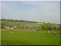
View from Pett Road
The slope at Borden Hill is in the distance.
Image: © Marathon
Taken: 11 Nov 2023
0.19 miles
7
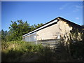
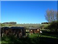
Little Pett Farm
Deans Hill topped by Frid Wood rises behind the farm buildings.
Image: © Penny Mayes
Taken: 22 Apr 2005
0.24 miles