IMAGES TAKEN NEAR TO
Bottom Pond Road, SITTINGBOURNE, ME9 0TR
Introduction
This page details the photographs taken nearby to Bottom Pond Road, ME9 0TR by members of the Geograph project.
The Geograph project started in 2005 with the aim of publishing, organising and preserving representative images for every square kilometre of Great Britain, Ireland and the Isle of Man.

There are currently over 7.5m images from over14,400 individuals and you can help contribute to the project by visiting https://www.geograph.org.uk
Image Map
Images are licensed for reuse under creativecommons.org/licenses/by-sa/2.0
Notes
- Clicking on the map will re-center to the selected point.
- The higher the marker number, the further away the image location is from the centre of the postcode.
Image Listing (29 Images Found)
Images are licensed for reuse under creativecommons.org/licenses/by-sa/2.0
Image
Details
Distance
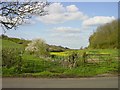
2
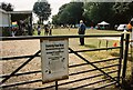
Wormshill Family Fun Day
Entrance gate to Wormshill Family Fun Day, 2009 at the village hall. Previously known as the village fete and, more recently, the country fair, this is the latest local incarnation of a very British event.
Image: © Richard Gibbard
Taken: 6 Sep 2009
0.05 miles
3
Stock Wood from the south east
That's the wood on the right, see the other end of this valley from TQ8958
Image: © Penny Mayes
Taken: 17 Apr 2005
0.09 miles
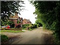
4

Manor House
As seen from bend in The Street, Wormshill.
Image: © David Anstiss
Taken: 29 Jan 2009
0.09 miles
5

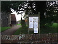
Wormshill Village Hall
On The Street, beside St Giles Church.
Image: © David Anstiss
Taken: 29 Jan 2009
0.09 miles
6
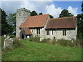
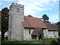
St Giles Church
The Church has Norman-era features and was substantially restored in 1879. It is dedicated to Saint Giles and contains a 13th century chest, a Norman font and a Tudor-era pulpit. The bells were restored in 1995 after a 50 year campaign.
Image: © Richard Gibbard
Taken: 9 Sep 2007
0.11 miles
7
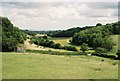
View across the Twin Hills
The hill valley between Wormshill and Frinsted. The area is known locally as the Twin Hills and is a popular sledging spot in winter as it is prone to heavy snowfalls. In the far distance is the bridge for the M2 motorway and beyond to The Swale and the Isle of Sheppey.
Image: © Richard Gibbard
Taken: 10 Aug 2009
0.11 miles
8

William Tylden's grave
Memorial stone for William Tylden, dated 1613. The Tylden family were a dominant landholding family in the area.
Image: © Richard Gibbard
Taken: 9 Sep 2007
0.11 miles