IMAGES TAKEN NEAR TO
Bottom Pond Road, SITTINGBOURNE, ME9 0TN
Introduction
This page details the photographs taken nearby to Bottom Pond Road, ME9 0TN by members of the Geograph project.
The Geograph project started in 2005 with the aim of publishing, organising and preserving representative images for every square kilometre of Great Britain, Ireland and the Isle of Man.

There are currently over 7.5m images from over14,400 individuals and you can help contribute to the project by visiting https://www.geograph.org.uk
Image Map
Images are licensed for reuse under creativecommons.org/licenses/by-sa/2.0
Notes
- Clicking on the map will re-center to the selected point.
- The higher the marker number, the further away the image location is from the centre of the postcode.
Image Listing (8 Images Found)
Images are licensed for reuse under creativecommons.org/licenses/by-sa/2.0
Image
Details
Distance
1

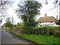
Norwood Farmhouse, Bottom Pond Road, near Frinsted
A Grade II listed building, 16th or 17th century.
Image: © pam fray
Taken: 10 Aug 2021
0.01 miles
2

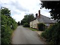
The Woodmans, Bottom Pond Road, near Frinsted
Grade II listed house, once a public house. Late 17th or early 18th century.
Image: © pam fray
Taken: 10 Aug 2021
0.04 miles
3
Norwood Farm
Looking north east along Bottom Pond Road.
Image: © Penny Mayes
Taken: 17 Apr 2005
0.04 miles
4
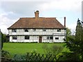
Norwood Farmhouse
The Grade II listing description is "GV II Farmhouse. Late C16 or early C17. Timber-framed with plaster infilling and plain tile roof. 2 storeys, close-studded, with continuous jetty. Broadly spaced studding to left, gable end. Hipped roof with gablets. Multiple corbelled brick ridge stack off-centre to left, and smaller stack to right end. Irregular fenestration of five C20 leaded casements. Central C20 boarded door. Right end bay possibly added, and ground floor built out in C20, timber-framed, rendered, with simple wood balustrade."
Image: © Penny Mayes
Taken: 17 Apr 2005
0.04 miles
6

Bottom Pond Road, near Frinsted
North of Norwood Farmhouse.
Image: © pam fray
Taken: 10 Aug 2021
0.08 miles
7
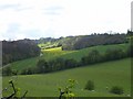
Stock Wood from the north east
One of many little valleys running down the north slope of the North Downs. The other end of the woods may be seen in TQ8857.
Stock Wood is the woodland on the left of the picture.
Image: © Penny Mayes
Taken: 17 Apr 2005
0.09 miles
8

View from Bottom Pond Road, near Frinsted
Looking across farmland towards the mouth of the River Medway.
Image: © pam fray
Taken: 10 Aug 2021
0.22 miles