IMAGES TAKEN NEAR TO
Frinsted, SITTINGBOURNE, ME9 0ST
Introduction
This page details the photographs taken nearby to ME9 0ST by members of the Geograph project.
The Geograph project started in 2005 with the aim of publishing, organising and preserving representative images for every square kilometre of Great Britain, Ireland and the Isle of Man.

There are currently over 7.5m images from over14,400 individuals and you can help contribute to the project by visiting https://www.geograph.org.uk
Image Map
Images are licensed for reuse under creativecommons.org/licenses/by-sa/2.0
Notes
- Clicking on the map will re-center to the selected point.
- The higher the marker number, the further away the image location is from the centre of the postcode.
Image Listing (5 Images Found)
Images are licensed for reuse under creativecommons.org/licenses/by-sa/2.0
Image
Details
Distance
1

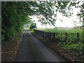
Yoke's Court
One of several fine old houses in the area. Photographed through a "window" in the relatively recent pleached hazel hedge.
Image: © Penny Mayes
Taken: 8 Jun 2005
0.00 miles
4
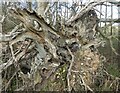
Roots of a dead tree, near Frinsted
The roots look like a striking modern sculpture.
Image: © pam fray
Taken: 19 Mar 2021
0.23 miles
5
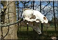
Skull on a dead, uprooted tree near Frinsted
Someone has hung what looks like a very clean rabbit's skull on a branch of the tree. Not a cute, furry bunny any more.
Image: © pam fray
Taken: 19 Mar 2021
0.23 miles