IMAGES TAKEN NEAR TO
Doddington, SITTINGBOURNE, ME9 0EA
Introduction
This page details the photographs taken nearby to ME9 0EA by members of the Geograph project.
The Geograph project started in 2005 with the aim of publishing, organising and preserving representative images for every square kilometre of Great Britain, Ireland and the Isle of Man.

There are currently over 7.5m images from over14,400 individuals and you can help contribute to the project by visiting https://www.geograph.org.uk
Image Map
Images are licensed for reuse under creativecommons.org/licenses/by-sa/2.0
Notes
- Clicking on the map will re-center to the selected point.
- The higher the marker number, the further away the image location is from the centre of the postcode.
Image Listing (5 Images Found)
Images are licensed for reuse under creativecommons.org/licenses/by-sa/2.0
Image
Details
Distance
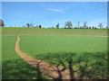
1
Field with sheep
South of Ringlestone Road.
Image: © Robin Webster
Taken: 8 Oct 2015
0.08 miles
2
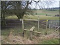
Stile on fence near Wrinsted Court
Path from West Street goes through valley and then through fields, then climbs over stile on access road to Wrinsted Court, then it goes downhill through sheep pasture to Ringlestone Road. Madam's Court is seen in far background on next hill.
Image: © David Anstiss
Taken: 22 Feb 2009
0.17 miles
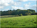
3

Barley near Madam's Court
Looking south from the centre of the square.
Image: © Penny Mayes
Taken: 8 Jun 2005
0.17 miles
4
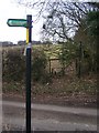
Footpath crosses Ringlestone Road
Path from Coalpit lane, passes Madam's Court, then over road, to lead through sheep pasture to Wrinsted Court and then on to West Street.
Image: © David Anstiss
Taken: 22 Feb 2009
0.18 miles