IMAGES TAKEN NEAR TO
Old Lenham Road, SITTINGBOURNE, ME9 0DS
Introduction
This page details the photographs taken nearby to Old Lenham Road, ME9 0DS by members of the Geograph project.
The Geograph project started in 2005 with the aim of publishing, organising and preserving representative images for every square kilometre of Great Britain, Ireland and the Isle of Man.

There are currently over 7.5m images from over14,400 individuals and you can help contribute to the project by visiting https://www.geograph.org.uk
Image Map
Images are licensed for reuse under creativecommons.org/licenses/by-sa/2.0
Notes
- Clicking on the map will re-center to the selected point.
- The higher the marker number, the further away the image location is from the centre of the postcode.
Image Listing (6 Images Found)
Images are licensed for reuse under creativecommons.org/licenses/by-sa/2.0
Image
Details
Distance
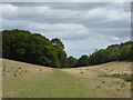
2
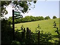
Meadow near Filmer Wood
The footpaths on both sides of the road here seem little used but maybe the nettles just grew very rapidly in the recent rain. I managed to miss a hare with my camera.
Image: © Penny Mayes
Taken: 8 Jun 2006
0.19 miles
3
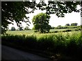
Oak among the rape
Single oak tree on a footpath from Broomhill Road to Wichling Wood.
Image: © Penny Mayes
Taken: 8 Jun 2006
0.21 miles
4
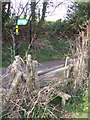
Footpath crosses Old Lenham Road
Path from Payden Street, passes through King's Acre wood then uphill past Filmer wood, then over stile and up steps to go through field to Faversham Road, Wichling.
Image: © David Anstiss
Taken: 24 Mar 2009
0.24 miles
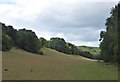
5
Path through a valley near Wichling
Looking north towards King's Acre Wood.
Image: © pam fray
Taken: 28 Jul 2020
0.24 miles
6
Path through a valley near Wichling
South of King's Acre Wood.
Image: © pam fray
Taken: 28 Jul 2020
0.25 miles