IMAGES TAKEN NEAR TO
Goodall Close, GILLINGHAM, ME8 9NG
Introduction
This page details the photographs taken nearby to Goodall Close, ME8 9NG by members of the Geograph project.
The Geograph project started in 2005 with the aim of publishing, organising and preserving representative images for every square kilometre of Great Britain, Ireland and the Isle of Man.

There are currently over 7.5m images from over14,400 individuals and you can help contribute to the project by visiting https://www.geograph.org.uk
Image Map
Images are licensed for reuse under creativecommons.org/licenses/by-sa/2.0
Notes
- Clicking on the map will re-center to the selected point.
- The higher the marker number, the further away the image location is from the centre of the postcode.
Image Listing (38 Images Found)
Images are licensed for reuse under creativecommons.org/licenses/by-sa/2.0
Image
Details
Distance
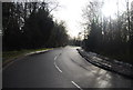
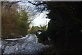
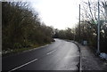
6
Miers Court Road
This part of Miers Court Road (formerly Chapel Lane) was by-passed following the construction of Dolphin Drive in 1984.
Image: © Chris Whippet
Taken: 17 Dec 2008
0.09 miles
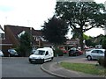
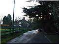
7
Mierscourt Road, Rainham
This narrow section of Mierscourt Road was bypassed following the road improvements when nearby Dolphin Drive was constructed in 1984.
Image: © Chris Whippet
Taken: 10 Jul 2015
0.09 miles
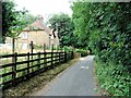
9
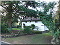
Hidden thatched cottage.
Hidden on Miers Court Road following the construction of Dolphin Drive, c.1984
Image: © Chris Whippet
Taken: 17 Dec 2008
0.10 miles