IMAGES TAKEN NEAR TO
Sutherland Gardens, GILLINGHAM, ME8 9LZ
Introduction
This page details the photographs taken nearby to Sutherland Gardens, ME8 9LZ by members of the Geograph project.
The Geograph project started in 2005 with the aim of publishing, organising and preserving representative images for every square kilometre of Great Britain, Ireland and the Isle of Man.

There are currently over 7.5m images from over14,400 individuals and you can help contribute to the project by visiting https://www.geograph.org.uk
Image Map (Loading...)


Getting Data...Please wait
Leaflet Map data © OpenStreetMap
Images are licensed for reuse under creativecommons.org/licenses/by-sa/2.0
Notes
- Clicking on the map will re-center to the selected point.
- The higher the marker number, the further away the image location is from the centre of the postcode.
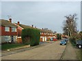
Image Listing (56 Images Found)
Images are licensed for reuse under creativecommons.org/licenses/by-sa/2.0
Image
Details
Distance
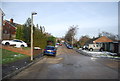
1
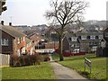
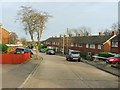
Sutherland Gardens, Parkwood
Housing on the steep slope east of Lonsdale Drive, southern Rainham. 50 years ago this was part of Rainham Park.
Image: © Penny Mayes
Taken: 15 Mar 2006
0.01 miles
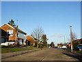
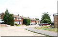
10
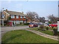
Barleycorn Drive, Parkwood
More of the vast housing estates that forms this part of upper Rainham.
Image: © Penny Mayes
Taken: 15 Mar 2006
0.07 miles