IMAGES TAKEN NEAR TO
Otterham Quay Lane, GILLINGHAM, ME8 8LL
Introduction
This page details the photographs taken nearby to Otterham Quay Lane, ME8 8LL by members of the Geograph project.
The Geograph project started in 2005 with the aim of publishing, organising and preserving representative images for every square kilometre of Great Britain, Ireland and the Isle of Man.

There are currently over 7.5m images from over14,400 individuals and you can help contribute to the project by visiting https://www.geograph.org.uk
Image Map
Images are licensed for reuse under creativecommons.org/licenses/by-sa/2.0
Notes
- Clicking on the map will re-center to the selected point.
- The higher the marker number, the further away the image location is from the centre of the postcode.
Image Listing (65 Images Found)
Images are licensed for reuse under creativecommons.org/licenses/by-sa/2.0
Image
Details
Distance
4
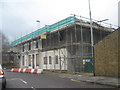
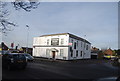
Construction work on former pub
This was the Men of Kent Pub, closed down last summer now looks like it is being turned into flats or offices
Image: © David Anstiss
Taken: 27 Feb 2010
0.05 miles
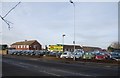
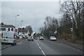
7
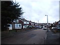
Junction of High Street & Moor Street from Meresborough Road
Image: © Oast House Archive
Taken: 17 Aug 2008
0.06 miles
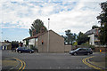
8
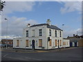
Men of Kent, Rainham
Looking west along the A2, High Street near its junction with Meresborough Road (left) and Otterham Quay Lane (right). The name of the pub reflects the fact that those born east of the river Medway are known as Men (or Maids) of Kent, whereas those from west of the river are Kentish Men (or Maids). Rainham has grown in all directions and is prime commuter belt for London.
Image: © Penny Mayes
Taken: 16 Jun 2006
0.06 miles
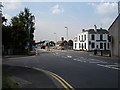
10
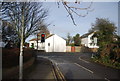
The end of Meresborough Rd
Here it meets the A2.
Image: © N Chadwick
Taken: 26 Jan 2013
0.07 miles