IMAGES TAKEN NEAR TO
Bloors Wharf Road, GILLINGHAM, ME8 7TW
Introduction
This page details the photographs taken nearby to Bloors Wharf Road, ME8 7TW by members of the Geograph project.
The Geograph project started in 2005 with the aim of publishing, organising and preserving representative images for every square kilometre of Great Britain, Ireland and the Isle of Man.

There are currently over 7.5m images from over14,400 individuals and you can help contribute to the project by visiting https://www.geograph.org.uk
Image Map (Loading...)


Getting Data...Please wait
Leaflet Map data © OpenStreetMap
Images are licensed for reuse under creativecommons.org/licenses/by-sa/2.0
Notes
- Clicking on the map will re-center to the selected point.
- The higher the marker number, the further away the image location is from the centre of the postcode.
Image Listing (56 Images Found)
Images are licensed for reuse under creativecommons.org/licenses/by-sa/2.0
Image
Details
Distance

2
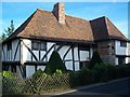
The Old house, Lower Rainham
On Lower Rainham road, near the Three mariners Pub.
Has small red plaque on the side of the building, (red brick section) which reads 'Historic Building in Kent'.
Image: © David Anstiss
Taken: 14 Nov 2008
0.06 miles

7
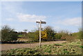
Signpost by the Saxon Shore Way, Bloors Wharf
Image: © N Chadwick
Taken: 5 Apr 2009
0.10 miles
8
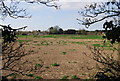
Looking SW from Bloors Wharf towards Lower Rainham
Image: © N Chadwick
Taken: 5 Apr 2009
0.10 miles
9
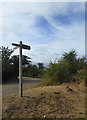
Signpost at Bloors Wharf
At the western end. The left hand sign points to Motney Hill, the right to Copperhouse Lane, Eastcourt Meadows, Sharps Green and Horrid Hill. The other post points to Lower Rainham Road. Part of the Saxon Shore Way at Riverside Country Park.
Image: © pam fray
Taken: 27 Sep 2016
0.11 miles
10
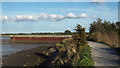
Saxon Shore Way at Bloor's Wharf, Lower Rainham
This path, through the Riverside Country Park, forms part of National Cycle Network route 1 which links Dover with the Shetland Islands.
Image: © Malc McDonald
Taken: 7 Sep 2013
0.12 miles