IMAGES TAKEN NEAR TO
Drewery Drive, GILLINGHAM, ME8 0NX
Introduction
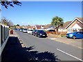
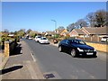
This page details the photographs taken nearby to Drewery Drive, ME8 0NX by members of the Geograph project.
The Geograph project started in 2005 with the aim of publishing, organising and preserving representative images for every square kilometre of Great Britain, Ireland and the Isle of Man.

There are currently over 7.5m images from over14,400 individuals and you can help contribute to the project by visiting https://www.geograph.org.uk
Image Map
Images are licensed for reuse under creativecommons.org/licenses/by-sa/2.0
Notes
- Clicking on the map will re-center to the selected point.
- The higher the marker number, the further away the image location is from the centre of the postcode.
Image Listing (40 Images Found)
Images are licensed for reuse under creativecommons.org/licenses/by-sa/2.0
Image
Details
Distance
2
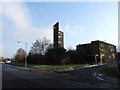
St. Matthews Church, Drewery Drive, Wigmore
Image: © Chris Whippet
Taken: 9 Jan 2009
0.03 miles
3
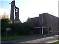
The Church and Community Centre of St Matthew, Wigmore
On Drewery Drive.
Abbeyfield House and Rogers House mentioned on sign, refer to residential homes for the Elderly on land at the back of the Church.
Image: © David Anstiss
Taken: 12 Nov 2008
0.03 miles
6
Entrance to Wigmore Park
Off Bredhurst Road.
Image: © Robin Webster
Taken: 25 Apr 2017
0.09 miles