IMAGES TAKEN NEAR TO
Marshall Road, GILLINGHAM, ME8 0AJ
Introduction
This page details the photographs taken nearby to Marshall Road, ME8 0AJ by members of the Geograph project.
The Geograph project started in 2005 with the aim of publishing, organising and preserving representative images for every square kilometre of Great Britain, Ireland and the Isle of Man.

There are currently over 7.5m images from over14,400 individuals and you can help contribute to the project by visiting https://www.geograph.org.uk
Image Map (Loading...)


Getting Data...Please wait
Leaflet Map data © OpenStreetMap
Images are licensed for reuse under creativecommons.org/licenses/by-sa/2.0
Notes
- Clicking on the map will re-center to the selected point.
- The higher the marker number, the further away the image location is from the centre of the postcode.
Image Listing (26 Images Found)
Images are licensed for reuse under creativecommons.org/licenses/by-sa/2.0
Image
Details
Distance
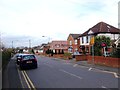
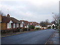
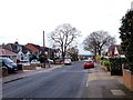
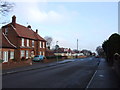
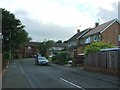
2
Junction of Edwin Road and Marshall Road, Rainham
Image: © Chris Whippet
Taken: 9 Jan 2009
0.02 miles
5
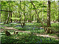
In East Hoath Wood, Rainham
A public wood.
Image: © Robin Webster
Taken: 25 Apr 2017
0.13 miles
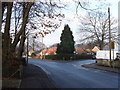
10

Path in East Hoath Wood, Wigmore
A path leads from Durham Road into the wood and then a path leads left towards Hoath Lane. Another lane leads straight on into the wood.
Image: © David Anstiss
Taken: 9 Feb 2013
0.17 miles