IMAGES TAKEN NEAR TO
High Street, GILLINGHAM, ME7 5AH
Introduction
This page details the photographs taken nearby to High Street, ME7 5AH by members of the Geograph project.
The Geograph project started in 2005 with the aim of publishing, organising and preserving representative images for every square kilometre of Great Britain, Ireland and the Isle of Man.

There are currently over 7.5m images from over14,400 individuals and you can help contribute to the project by visiting https://www.geograph.org.uk
Image Map
Images are licensed for reuse under creativecommons.org/licenses/by-sa/2.0
Notes
- Clicking on the map will re-center to the selected point.
- The higher the marker number, the further away the image location is from the centre of the postcode.
Image Listing (396 Images Found)
Images are licensed for reuse under creativecommons.org/licenses/by-sa/2.0
Image
Details
Distance
1
Lord Nelson, Wood Street, Brompton
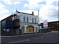
The old Lord Nelson pub.
Image: © Chris Whippet
Taken: 19 Jun 2009
0.01 miles
6
The Royal Marine Public House
On River Street, opposite Chatham Dockyard.
Image: © David Anstiss
Taken: 3 Nov 2008
0.04 miles
8
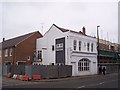
Building Site on Wood Street
This former car dealership on the junction of Wood Street (on the right) and Manor Street (on the left) is now being turned into flats for a housing association.
Image: © David Anstiss
Taken: 22 Jan 2010
0.04 miles