IMAGES TAKEN NEAR TO
Barnsole Road, GILLINGHAM, ME7 4JJ
Introduction
This page details the photographs taken nearby to Barnsole Road, ME7 4JJ by members of the Geograph project.
The Geograph project started in 2005 with the aim of publishing, organising and preserving representative images for every square kilometre of Great Britain, Ireland and the Isle of Man.

There are currently over 7.5m images from over14,400 individuals and you can help contribute to the project by visiting https://www.geograph.org.uk
Image Map
Images are licensed for reuse under creativecommons.org/licenses/by-sa/2.0
Notes
- Clicking on the map will re-center to the selected point.
- The higher the marker number, the further away the image location is from the centre of the postcode.
Image Listing (53 Images Found)
Images are licensed for reuse under creativecommons.org/licenses/by-sa/2.0
Image
Details
Distance
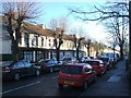
5
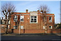
Canada House, Larkfield Rd
Was a naval military hospital, now an NHS building.
Image: © N Chadwick
Taken: 31 Jan 2009
0.06 miles
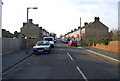
10
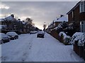
Cleave Road
This road leads from Oxford Road to the A2 Watling Street. Very few cars moving on the icy and snow covered roads.
Image: © David Anstiss
Taken: 7 Jan 2010
0.10 miles