IMAGES TAKEN NEAR TO
Barnsole Road, GILLINGHAM, ME7 4EA
Introduction
This page details the photographs taken nearby to Barnsole Road, ME7 4EA by members of the Geograph project.
The Geograph project started in 2005 with the aim of publishing, organising and preserving representative images for every square kilometre of Great Britain, Ireland and the Isle of Man.

There are currently over 7.5m images from over14,400 individuals and you can help contribute to the project by visiting https://www.geograph.org.uk
Image Map
Images are licensed for reuse under creativecommons.org/licenses/by-sa/2.0
Notes
- Clicking on the map will re-center to the selected point.
- The higher the marker number, the further away the image location is from the centre of the postcode.
Image Listing (102 Images Found)
Images are licensed for reuse under creativecommons.org/licenses/by-sa/2.0
Image
Details
Distance
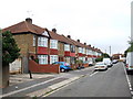
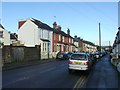
4
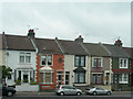
Houses on Barnsole Road, Gillingham
At the junction with Sturdee Avenue.
Image: © Danny P Robinson
Taken: 15 Jul 2008
0.06 miles
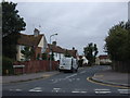
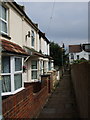
5
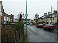
Harold Avenue, Gillingham
The floodlights at Priestfield Stadium are visible in the background.
Image: © Danny P Robinson
Taken: 23 Mar 2008
0.06 miles