IMAGES TAKEN NEAR TO
Chester Road, GILLINGHAM, ME7 4AF
Introduction
This page details the photographs taken nearby to Chester Road, ME7 4AF by members of the Geograph project.
The Geograph project started in 2005 with the aim of publishing, organising and preserving representative images for every square kilometre of Great Britain, Ireland and the Isle of Man.

There are currently over 7.5m images from over14,400 individuals and you can help contribute to the project by visiting https://www.geograph.org.uk
Image Map
Images are licensed for reuse under creativecommons.org/licenses/by-sa/2.0
Notes
- Clicking on the map will re-center to the selected point.
- The higher the marker number, the further away the image location is from the centre of the postcode.
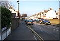
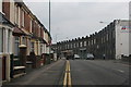
Image Listing (101 Images Found)
Images are licensed for reuse under creativecommons.org/licenses/by-sa/2.0
Image
Details
Distance
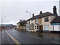
4
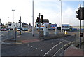
Junction of Rainham Rd, A2 & Canterbury St A231
Road junction to leave the A2, to get to the centre of Gillingham
Image: © N Chadwick
Taken: 31 Jan 2009
0.05 miles


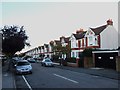
10
Canterbury Street, Gillingham facing South
Just below junction with A2, the building with castellations on the right is what is left of the 'Jezreels Tower'.
Image: © Steve Wheeler
Taken: 20 Aug 2005
0.06 miles