IMAGES TAKEN NEAR TO
Wildwood Glade, GILLINGHAM, ME7 3SX
Introduction
This page details the photographs taken nearby to Wildwood Glade, ME7 3SX by members of the Geograph project.
The Geograph project started in 2005 with the aim of publishing, organising and preserving representative images for every square kilometre of Great Britain, Ireland and the Isle of Man.

There are currently over 7.5m images from over14,400 individuals and you can help contribute to the project by visiting https://www.geograph.org.uk
Image Map
Images are licensed for reuse under creativecommons.org/licenses/by-sa/2.0
Notes
- Clicking on the map will re-center to the selected point.
- The higher the marker number, the further away the image location is from the centre of the postcode.
Image Listing (74 Images Found)
Images are licensed for reuse under creativecommons.org/licenses/by-sa/2.0
Image
Details
Distance
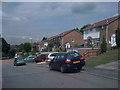
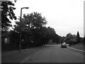
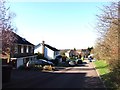
1
Spekes Road, Hempstead
Now used as a footpath.
Image: © Chris Whippet
Taken: 9 Dec 2011
0.01 miles
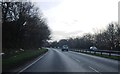
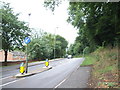
3
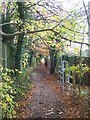
Bridleway in Wildwood Glade
Runs along A278 (dual carriageway) Hoath Way (green metal fence on left).
Goes from Kingsdown Close to Fairview Avenue (behind viewer).
Access on right is from Wildwood Glade Road.
Image: © David Anstiss
Taken: 12 Nov 2008
0.04 miles