IMAGES TAKEN NEAR TO
Hempstead Road, GILLINGHAM, ME7 3SA
Introduction
This page details the photographs taken nearby to Hempstead Road, ME7 3SA by members of the Geograph project.
The Geograph project started in 2005 with the aim of publishing, organising and preserving representative images for every square kilometre of Great Britain, Ireland and the Isle of Man.

There are currently over 7.5m images from over14,400 individuals and you can help contribute to the project by visiting https://www.geograph.org.uk
Image Map
Images are licensed for reuse under creativecommons.org/licenses/by-sa/2.0
Notes
- Clicking on the map will re-center to the selected point.
- The higher the marker number, the further away the image location is from the centre of the postcode.
Image Listing (75 Images Found)
Images are licensed for reuse under creativecommons.org/licenses/by-sa/2.0
Image
Details
Distance
1
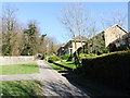
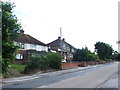
Hospital Hill, Hempstead
Leading under the A278 towards Hoath Lane in Wigmore, Hospital Hill used to be the access road to Hempstead Isolation Hospital which was located to the left. The houses on the right were constructed in the mid 1970s and have Hempstead Road addresses.
Image: © Chris Whippet
Taken: 16 Mar 2014
0.01 miles
4

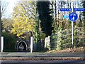
Subway under Hoath Way, Wigmore
A footpath leads from Hempstead Road, under the Hoath Way (the A278 dual carriageway). The path then heads towards Hoath Lane.
Image: © David Anstiss
Taken: 6 Apr 2013
0.05 miles
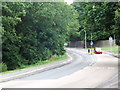
6
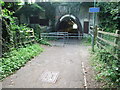
Subway under the A278
This subway runs under the A278 between Hoath Lane in Wigmore and Hempstead Road. Before the A278's construction in the mid-1960s this route was named Hospital Hill, due to Hempstead isolation hospital which was located to the right of this picture.
Image: © Chris Whippet
Taken: 21 Jun 2010
0.06 miles
8
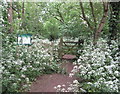
Gate near Hempstead Road to
A path leads from Hempstead Road to head up to Hoath Wood via a local nature reserve.
Loads of frothing white cow parsley line the route.
Image: © David Anstiss
Taken: 24 May 2015
0.08 miles
9
Subway under Hoath Way, Wigmore
On Hoath Lane. Footpath leads to Hempstead.
Hoath (Dual Carriageway - A278), goes from M2 junction 4 (on left), towards Gillingham/Chatham/A2 (on right).
Image: © David Anstiss
Taken: 12 Nov 2008
0.08 miles
10
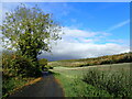
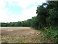
Autumn countryside near Gillingham
This is Star Lane which leads to surprisingly remote countryside to the south of Gillingham. It is a dead end for cars but a path continues beyond barriers to meet the southern end of Gillingham.
Image: © Marathon
Taken: 29 Oct 2024
0.08 miles