IMAGES TAKEN NEAR TO
Water Meadow Close, GILLINGHAM, ME7 3QF
Introduction
This page details the photographs taken nearby to Water Meadow Close, ME7 3QF by members of the Geograph project.
The Geograph project started in 2005 with the aim of publishing, organising and preserving representative images for every square kilometre of Great Britain, Ireland and the Isle of Man.

There are currently over 7.5m images from over14,400 individuals and you can help contribute to the project by visiting https://www.geograph.org.uk
Image Map
Images are licensed for reuse under creativecommons.org/licenses/by-sa/2.0
Notes
- Clicking on the map will re-center to the selected point.
- The higher the marker number, the further away the image location is from the centre of the postcode.
Image Listing (57 Images Found)
Images are licensed for reuse under creativecommons.org/licenses/by-sa/2.0
Image
Details
Distance
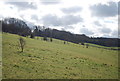
10
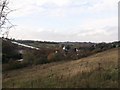
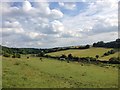
View of Capstone Valley
As seen from a footpath from Capstone Road up towards Pear Tree Lane.
In the background, the ski centre, Oast House (youth hostel) and parts of Capstone Valley Country Park.
Image: © David Anstiss
Taken: 17 Nov 2011
0.12 miles