IMAGES TAKEN NEAR TO
The Street, GILLINGHAM, ME7 3LJ
Introduction
This page details the photographs taken nearby to The Street, ME7 3LJ by members of the Geograph project.
The Geograph project started in 2005 with the aim of publishing, organising and preserving representative images for every square kilometre of Great Britain, Ireland and the Isle of Man.

There are currently over 7.5m images from over14,400 individuals and you can help contribute to the project by visiting https://www.geograph.org.uk
Image Map (Loading...)


Getting Data...Please wait
Leaflet Map data © OpenStreetMap
Images are licensed for reuse under creativecommons.org/licenses/by-sa/2.0
Notes
- Clicking on the map will re-center to the selected point.
- The higher the marker number, the further away the image location is from the centre of the postcode.
Image Listing (67 Images Found)
Images are licensed for reuse under creativecommons.org/licenses/by-sa/2.0
Image
Details
Distance
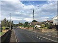
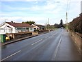
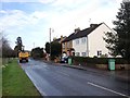
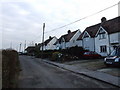
1
The Street, Bredhurst
Just ahead, beyond Bredhurst, the road becomes Maidstone Road and passes over the M2 and under Hoath Way to meet Wigmore Road on the outskirts of Rainham.
Image: © Marathon
Taken: 29 Oct 2024
0.04 miles
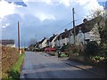
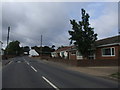
5
Cottages off Kemsley Street Road
A row of four, looking as if built for the local estate.
Image: © Robin Webster
Taken: 23 Jun 2012
0.08 miles
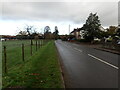
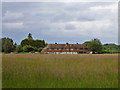
7
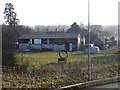
Abbot's Court Farm
Immediately south of the M2 (visible in the foreground) near junction 4 on the northern edge of Bredhurst village.
Image: © Penny Mayes
Taken: 15 Mar 2006
0.08 miles