IMAGES TAKEN NEAR TO
Hurstwood Road, GILLINGHAM, ME7 3LA
Introduction
This page details the photographs taken nearby to Hurstwood Road, ME7 3LA by members of the Geograph project.
The Geograph project started in 2005 with the aim of publishing, organising and preserving representative images for every square kilometre of Great Britain, Ireland and the Isle of Man.

There are currently over 7.5m images from over14,400 individuals and you can help contribute to the project by visiting https://www.geograph.org.uk
Image Map
Images are licensed for reuse under creativecommons.org/licenses/by-sa/2.0
Notes
- Clicking on the map will re-center to the selected point.
- The higher the marker number, the further away the image location is from the centre of the postcode.
Image Listing (42 Images Found)
Images are licensed for reuse under creativecommons.org/licenses/by-sa/2.0
Image
Details
Distance
4
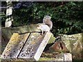
Squirrel in Bredhurst Church Cemetery
On Hurstwood Road.
Was eating a yew tree berry, ? not poisonous to them ?
Image: © David Anstiss
Taken: 12 Nov 2008
0.08 miles
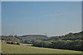
6
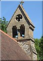
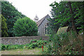
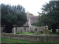
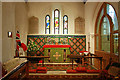
St. Peter's Church, Bredhurst
The double bell-cote at the eastern end of the building. The parish Church, originally Norman and 13th century but heavily restored in 1866. It is a Grade II listed building.
Image: © pam fray
Taken: 22 Jun 2020
0.08 miles