IMAGES TAKEN NEAR TO
Windyridge, GILLINGHAM, ME7 3BB
Introduction
This page details the photographs taken nearby to Windyridge, ME7 3BB by members of the Geograph project.
The Geograph project started in 2005 with the aim of publishing, organising and preserving representative images for every square kilometre of Great Britain, Ireland and the Isle of Man.

There are currently over 7.5m images from over14,400 individuals and you can help contribute to the project by visiting https://www.geograph.org.uk
Image Map
Images are licensed for reuse under creativecommons.org/licenses/by-sa/2.0
Notes
- Clicking on the map will re-center to the selected point.
- The higher the marker number, the further away the image location is from the centre of the postcode.
Image Listing (66 Images Found)
Images are licensed for reuse under creativecommons.org/licenses/by-sa/2.0
Image
Details
Distance
7
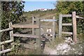
Kissing Gate in Darland Banks
This gate is on a footpath from Star Lane towards Ash Tree Lane. Kingsway houses are seen in the background
Image: © David Anstiss
Taken: 24 Sep 2009
0.09 miles
8
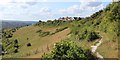
Darland Bands & Chatham
See more sizes for full panorama.
Image: © Oast House Archive
Taken: 3 Aug 2014
0.11 miles
10
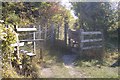
Stile and Kissing Gate in Darland Banks
The gate is on a public footpath from Ash Tree Lane, through Darland Bank Nature Reserve towards Star Lane. The stile is on a path from Kingsway to the reserve.
Image: © David Anstiss
Taken: 24 Sep 2009
0.12 miles