IMAGES TAKEN NEAR TO
Lower Rainham Road, GILLINGHAM, ME7 2XH
Introduction
This page details the photographs taken nearby to Lower Rainham Road, ME7 2XH by members of the Geograph project.
The Geograph project started in 2005 with the aim of publishing, organising and preserving representative images for every square kilometre of Great Britain, Ireland and the Isle of Man.

There are currently over 7.5m images from over14,400 individuals and you can help contribute to the project by visiting https://www.geograph.org.uk
Image Map (Loading...)


Getting Data...Please wait
Leaflet Map data © OpenStreetMap
Images are licensed for reuse under creativecommons.org/licenses/by-sa/2.0
Notes
- Clicking on the map will re-center to the selected point.
- The higher the marker number, the further away the image location is from the centre of the postcode.
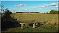
Image Listing (77 Images Found)
Images are licensed for reuse under creativecommons.org/licenses/by-sa/2.0
Image
Details
Distance
1
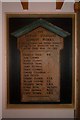
Memorial Plaque
This memorial to 14 men of the British Standard Cement Company's works at Motney Hill who died in World War 1, is mounted inside the visitor centre at Riverside Country Park. The cement works operated from 1912 to 1931 and again briefly in the late 30's early 40's, before lying derelict and being finally demolished during the 1950's and 60's
Image: © Brian Baker
Taken: 17 Sep 2008
0.11 miles
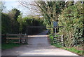
3
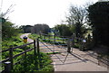
Gate on The Saxon Shore Way, Sharp's Green
Image: © N Chadwick
Taken: 5 Apr 2009
0.14 miles
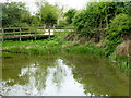
4
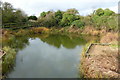
Sharp's Green Pond, Riverside Country Park
A small freshwater pond inside the clay sea wall, which is used to promote a diversity of wildlife within the park. Riverside Country Park is a large coastal public park, situated alongside the River Medway estuary between Gillingham and Rainham. The park covers about 100 hectares.
Image: © pam fray
Taken: 17 Apr 2017
0.14 miles
5
Sharp's Green Pond, Riverside Country Park, near Rainham
A small freshwater pond inside the clay sea wall, which is used to promote a diversity of wildlife within the park. Riverside Country Park is a large coastal public park, situated alongside the River Medway estuary between Gillingham and Rainham. The park covers about 100 hectares.
Image: © pam fray
Taken: 17 Apr 2017
0.14 miles
7

View of the Medway from a Southeastern High Speed train #3
Looking north-northeast further along the line between Gillingham and Rainham stations.
Image: © Robert Lamb
Taken: 16 Jun 2012
0.15 miles
8
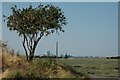
Gillingham Riverside Country Park
looking towards Kingsnorth Power Station across the River Medway just to the right of Sharps Green
Image: © Glen Diamond
Taken: 17 Jul 2005
0.15 miles
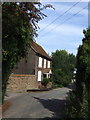
10
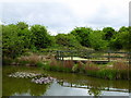
Riverside Country Park, near Gillingham
Image: © Malc McDonald
Taken: 7 Sep 2013
0.16 miles