IMAGES TAKEN NEAR TO
Grange Road, GILLINGHAM, ME7 2UH
Introduction
This page details the photographs taken nearby to Grange Road, ME7 2UH by members of the Geograph project.
The Geograph project started in 2005 with the aim of publishing, organising and preserving representative images for every square kilometre of Great Britain, Ireland and the Isle of Man.

There are currently over 7.5m images from over14,400 individuals and you can help contribute to the project by visiting https://www.geograph.org.uk
Image Map
Images are licensed for reuse under creativecommons.org/licenses/by-sa/2.0
Notes
- Clicking on the map will re-center to the selected point.
- The higher the marker number, the further away the image location is from the centre of the postcode.
Image Listing (17 Images Found)
Images are licensed for reuse under creativecommons.org/licenses/by-sa/2.0
Image
Details
Distance
2
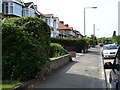
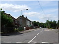
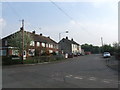
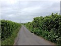
Ladds Corner, Lower Twydall
There is housing only on the south side of this road and they must have a fine view of the Medway Estuary from the upstairs windows.
Image: © Penny Mayes
Taken: 16 Jun 2006
0.06 miles
10
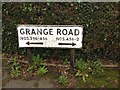
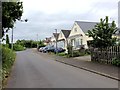
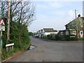
Vintage street nameplate, Grange Road, Grange
Access to 456-2 has now been obstructed by the construction of the A289 in the mid 1990s.
Image: © Chris Whippet
Taken: 26 Oct 2014
0.21 miles