IMAGES TAKEN NEAR TO
Hazlemere Drive, GILLINGHAM, ME7 2TF
Introduction
This page details the photographs taken nearby to Hazlemere Drive, ME7 2TF by members of the Geograph project.
The Geograph project started in 2005 with the aim of publishing, organising and preserving representative images for every square kilometre of Great Britain, Ireland and the Isle of Man.

There are currently over 7.5m images from over14,400 individuals and you can help contribute to the project by visiting https://www.geograph.org.uk
Image Map
Images are licensed for reuse under creativecommons.org/licenses/by-sa/2.0
Notes
- Clicking on the map will re-center to the selected point.
- The higher the marker number, the further away the image location is from the centre of the postcode.
Image Listing (49 Images Found)
Images are licensed for reuse under creativecommons.org/licenses/by-sa/2.0
Image
Details
Distance
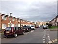
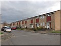
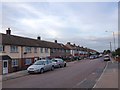
4

Tangmere Close
Terrace housing estate off Woodlands Road.
Image: © Oast House Archive
Taken: 26 Feb 2012
0.09 miles
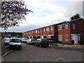
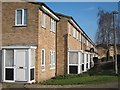
6

Braithwaite Court, Gillingham
Large block of flats on Tangmere Close.
Image: © David Anstiss
Taken: 4 Dec 2011
0.09 miles
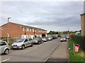
7
Tangmere Close
Terrace housing estate off Woodlands Road.
Image: © Oast House Archive
Taken: 26 Feb 2012
0.10 miles
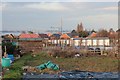
9

Snow covered path in Woodlands Road Allotments
This concrete track looks to have been used by one car to check on his/her plot and nobody else!
Image: © David Anstiss
Taken: 5 Feb 2012
0.11 miles