IMAGES TAKEN NEAR TO
King Edward Road, GILLINGHAM, ME7 2RG
Introduction
This page details the photographs taken nearby to King Edward Road, ME7 2RG by members of the Geograph project.
The Geograph project started in 2005 with the aim of publishing, organising and preserving representative images for every square kilometre of Great Britain, Ireland and the Isle of Man.

There are currently over 7.5m images from over14,400 individuals and you can help contribute to the project by visiting https://www.geograph.org.uk
Image Map
Images are licensed for reuse under creativecommons.org/licenses/by-sa/2.0
Notes
- Clicking on the map will re-center to the selected point.
- The higher the marker number, the further away the image location is from the centre of the postcode.
Image Listing (113 Images Found)
Images are licensed for reuse under creativecommons.org/licenses/by-sa/2.0
Image
Details
Distance
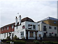
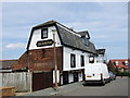
6

The Ship Public House
A289 dual carriageway behind the pub.
On Court Lodge Road, stops at Pub.
Image: © David Anstiss
Taken: 16 Oct 2008
0.06 miles
10
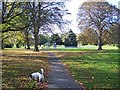
Cemetery / Playing Fields of St Mary's Church
St Mary's Church is straight along the footpath and up the slight hill.
Image: © David Anstiss
Taken: 16 Oct 2008
0.07 miles