IMAGES TAKEN NEAR TO
Waterside Lane, GILLINGHAM, ME7 2JA
Introduction
This page details the photographs taken nearby to Waterside Lane, ME7 2JA by members of the Geograph project.
The Geograph project started in 2005 with the aim of publishing, organising and preserving representative images for every square kilometre of Great Britain, Ireland and the Isle of Man.

There are currently over 7.5m images from over14,400 individuals and you can help contribute to the project by visiting https://www.geograph.org.uk
Image Map
Images are licensed for reuse under creativecommons.org/licenses/by-sa/2.0
Notes
- Clicking on the map will re-center to the selected point.
- The higher the marker number, the further away the image location is from the centre of the postcode.
Image Listing (98 Images Found)
Images are licensed for reuse under creativecommons.org/licenses/by-sa/2.0
Image
Details
Distance
2
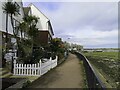
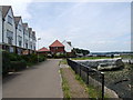
The Saxon Shore Way by Gillingham Marshes
Image: © Steve Daniels
Taken: 10 Oct 2020
0.02 miles
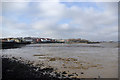
4
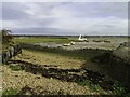
Shingle foreshore by Gillingham Marshes
Image: © Steve Daniels
Taken: 10 Oct 2020
0.03 miles
5
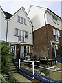
Weatherboarded Cottages, Gillingham Reach (2)
Image: © N Chadwick
Taken: 5 Apr 2009
0.03 miles
6
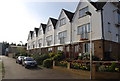
Weatherboarded Cottages, Gillingham Reach (3)
Image: © N Chadwick
Taken: 5 Apr 2009
0.03 miles
8
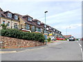
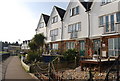
Riverside Housing, Gillingham
Overlooking the Medway Estuary, near the Strand.
Image: © Danny P Robinson
Taken: 26 Jul 2008
0.04 miles
10
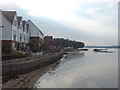
Waterfront, Gillingham
Or mudfront as seen, and for a lot of the time.
Image: © Robin Webster
Taken: 4 Feb 2007
0.04 miles