IMAGES TAKEN NEAR TO
Glebe Road, GILLINGHAM, ME7 2HU
Introduction
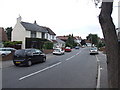
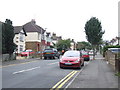
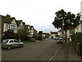
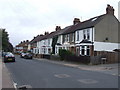
This page details the photographs taken nearby to Glebe Road, ME7 2HU by members of the Geograph project.
The Geograph project started in 2005 with the aim of publishing, organising and preserving representative images for every square kilometre of Great Britain, Ireland and the Isle of Man.

There are currently over 7.5m images from over14,400 individuals and you can help contribute to the project by visiting https://www.geograph.org.uk
Image Map
Images are licensed for reuse under creativecommons.org/licenses/by-sa/2.0
Notes
- Clicking on the map will re-center to the selected point.
- The higher the marker number, the further away the image location is from the centre of the postcode.
Image Listing (49 Images Found)
Images are licensed for reuse under creativecommons.org/licenses/by-sa/2.0
Image
Details
Distance


8

Gillingham Golf Course (part 2)
Divided by Woodlands Road, Gillingham Golf Course is split in two parts.
The West side of the course, has holes 2 to 10 and 15 to 17.
The East side of the course, has hole 1, holes 11 to 14 and hole 18, and also the Clubhouse.
Image: © David Anstiss
Taken: 16 Oct 2008
0.13 miles