IMAGES TAKEN NEAR TO
Church Street, GILLINGHAM, ME7 1TR
Introduction
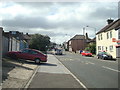
This page details the photographs taken nearby to Church Street, ME7 1TR by members of the Geograph project.
The Geograph project started in 2005 with the aim of publishing, organising and preserving representative images for every square kilometre of Great Britain, Ireland and the Isle of Man.

There are currently over 7.5m images from over14,400 individuals and you can help contribute to the project by visiting https://www.geograph.org.uk
Image Map
Images are licensed for reuse under creativecommons.org/licenses/by-sa/2.0
Notes
- Clicking on the map will re-center to the selected point.
- The higher the marker number, the further away the image location is from the centre of the postcode.
Image Listing (154 Images Found)
Images are licensed for reuse under creativecommons.org/licenses/by-sa/2.0
Image
Details
Distance
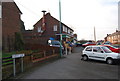
3
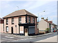
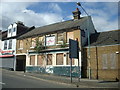
Disused Shop, Gillingham
On the corner of Church Street and Forge Lane.
Image: © Chris Whippet
Taken: 12 Jun 2009
0.01 miles
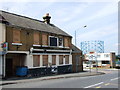
5
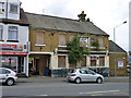
Former Green Dragon pub, Church Street, Gillingham
This was later demolished.
Image: © Robin Webster
Taken: 23 Jun 2012
0.02 miles
8
The Green Dragon public house, Gillingham
Image: © Stacey Harris
Taken: 30 Aug 2010
0.03 miles