IMAGES TAKEN NEAR TO
Hamilton Road, GILLINGHAM, ME7 1QL
Introduction
This page details the photographs taken nearby to Hamilton Road, ME7 1QL by members of the Geograph project.
The Geograph project started in 2005 with the aim of publishing, organising and preserving representative images for every square kilometre of Great Britain, Ireland and the Isle of Man.

There are currently over 7.5m images from over14,400 individuals and you can help contribute to the project by visiting https://www.geograph.org.uk
Image Map
Images are licensed for reuse under creativecommons.org/licenses/by-sa/2.0
Notes
- Clicking on the map will re-center to the selected point.
- The higher the marker number, the further away the image location is from the centre of the postcode.
Image Listing (165 Images Found)
Images are licensed for reuse under creativecommons.org/licenses/by-sa/2.0
Image
Details
Distance
1
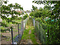
Path from Milner Road to Hamilton Road, Gillingham
Running between allotments.
Image: © Robin Webster
Taken: 23 Jun 2012
0.02 miles
2
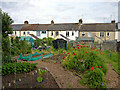
Allotments behind Corporation Road
A small area split in two by a path from Milner Road.
Image: © Robin Webster
Taken: 23 Jun 2012
0.03 miles
6
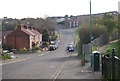
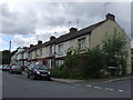
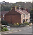
Corporation Road, Gillingham (1)
Looking downhill, showing houses that would have been built in the late 19th Century. This is a link to the photo taken in the opposite direction. Image
Image: © Danny P Robinson
Taken: 1 Jan 2008
0.07 miles
8
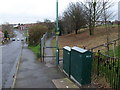
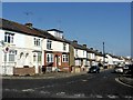
Church Path (the western end)
The view eastwards.
Image: © Michael Flegg
Taken: 27 Nov 2008
0.08 miles