IMAGES TAKEN NEAR TO
Saunders Street, GILLINGHAM, ME7 1HY
Introduction
This page details the photographs taken nearby to Saunders Street, ME7 1HY by members of the Geograph project.
The Geograph project started in 2005 with the aim of publishing, organising and preserving representative images for every square kilometre of Great Britain, Ireland and the Isle of Man.

There are currently over 7.5m images from over14,400 individuals and you can help contribute to the project by visiting https://www.geograph.org.uk
Image Map
Images are licensed for reuse under creativecommons.org/licenses/by-sa/2.0
Notes
- Clicking on the map will re-center to the selected point.
- The higher the marker number, the further away the image location is from the centre of the postcode.
Image Listing (322 Images Found)
Images are licensed for reuse under creativecommons.org/licenses/by-sa/2.0
Image
Details
Distance
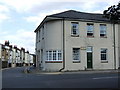
1
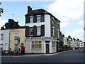
Junction of Mill Road and Saunders Street, Gillingham
The building in the centre was formerly a shop.
Image: © Chris Whippet
Taken: 5 Jul 2010
0.01 miles
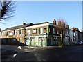

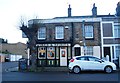
10
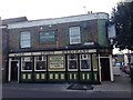
The Countryman, Gillingham
Formerly the Ghuznee Fort.
Image: © Chris Whippet
Taken: 27 Oct 2014
0.03 miles