IMAGES TAKEN NEAR TO
Holborough Road, SNODLAND, ME6 5PB
Introduction
This page details the photographs taken nearby to Holborough Road, ME6 5PB by members of the Geograph project.
The Geograph project started in 2005 with the aim of publishing, organising and preserving representative images for every square kilometre of Great Britain, Ireland and the Isle of Man.

There are currently over 7.5m images from over14,400 individuals and you can help contribute to the project by visiting https://www.geograph.org.uk
Image Map
Images are licensed for reuse under creativecommons.org/licenses/by-sa/2.0
Notes
- Clicking on the map will re-center to the selected point.
- The higher the marker number, the further away the image location is from the centre of the postcode.
Image Listing (105 Images Found)
Images are licensed for reuse under creativecommons.org/licenses/by-sa/2.0
Image
Details
Distance
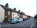
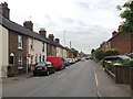
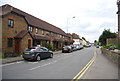
2
Terrace on Holborough Road, Snodland
On the old main road which is now bypassed.
Image: © Robin Webster
Taken: 13 Jun 2012
0.01 miles
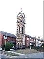
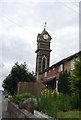
4
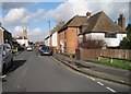
Holborough Road and Snodland Clock Tower
Image: © Nigel Thompson
Taken: 7 Feb 2017
0.03 miles