IMAGES TAKEN NEAR TO
Holborough Road, SNODLAND, ME6 5NJ
Introduction
This page details the photographs taken nearby to Holborough Road, ME6 5NJ by members of the Geograph project.
The Geograph project started in 2005 with the aim of publishing, organising and preserving representative images for every square kilometre of Great Britain, Ireland and the Isle of Man.

There are currently over 7.5m images from over14,400 individuals and you can help contribute to the project by visiting https://www.geograph.org.uk
Image Map
Images are licensed for reuse under creativecommons.org/licenses/by-sa/2.0
Notes
- Clicking on the map will re-center to the selected point.
- The higher the marker number, the further away the image location is from the centre of the postcode.
Image Listing (148 Images Found)
Images are licensed for reuse under creativecommons.org/licenses/by-sa/2.0
Image
Details
Distance
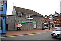
2
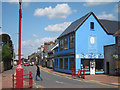
China Chaps
Shop on Malling Road.
Image: © Oast House Archive
Taken: 24 Jul 2011
0.03 miles
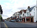
5
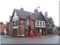
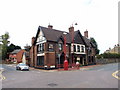
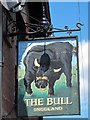
The Bull Pub, Snodland
On junction of High Street and Holborough Road.
Note, red painted street furniture, obviously Tonbridge and Malling Council has more money to spend than other councils....
Image: © David Anstiss
Taken: 12 Dec 2008
0.03 miles