IMAGES TAKEN NEAR TO
Ostlers Court, SNODLAND, ME6 5NF
Introduction
This page details the photographs taken nearby to Ostlers Court, ME6 5NF by members of the Geograph project.
The Geograph project started in 2005 with the aim of publishing, organising and preserving representative images for every square kilometre of Great Britain, Ireland and the Isle of Man.

There are currently over 7.5m images from over14,400 individuals and you can help contribute to the project by visiting https://www.geograph.org.uk
Image Map (Loading...)


Getting Data...Please wait
Leaflet Map data © OpenStreetMap
Images are licensed for reuse under creativecommons.org/licenses/by-sa/2.0
Notes
- Clicking on the map will re-center to the selected point.
- The higher the marker number, the further away the image location is from the centre of the postcode.
Image Listing (159 Images Found)
Images are licensed for reuse under creativecommons.org/licenses/by-sa/2.0
Image
Details
Distance
2
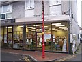
Snodland Library
On the High Street. Small building like an office, in a block of shops.
Image: © David Anstiss
Taken: 12 Dec 2008
0.03 miles
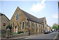
3
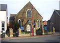
United Reformed Methodist Church, Snodland
Built in 1888, this church stands in the High Street on the corner of Queens Avenue.
Image: © Richard Dorrell
Taken: 22 Jan 2008
0.03 miles

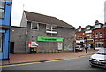
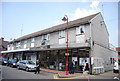
7
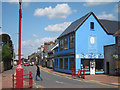
China Chaps
Shop on Malling Road.
Image: © Oast House Archive
Taken: 24 Jul 2011
0.04 miles