IMAGES TAKEN NEAR TO
Brook Lane, SNODLAND, ME6 5JX
Introduction
This page details the photographs taken nearby to Brook Lane, ME6 5JX by members of the Geograph project.
The Geograph project started in 2005 with the aim of publishing, organising and preserving representative images for every square kilometre of Great Britain, Ireland and the Isle of Man.

There are currently over 7.5m images from over14,400 individuals and you can help contribute to the project by visiting https://www.geograph.org.uk
Image Map
Images are licensed for reuse under creativecommons.org/licenses/by-sa/2.0
Notes
- Clicking on the map will re-center to the selected point.
- The higher the marker number, the further away the image location is from the centre of the postcode.
Image Listing (29 Images Found)
Images are licensed for reuse under creativecommons.org/licenses/by-sa/2.0
Image
Details
Distance
2
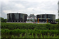
Sewage works tanks, Snodland
These must be a recent installation, as the area within the works here is mapped as open ground.
Image: © Robin Webster
Taken: 13 Jun 2012
0.04 miles
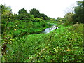
4
Drain, Leybourne Lakes Country Park
The western boundary of the park, a sewage works is beyond.
Image: © Robin Webster
Taken: 13 Jun 2012
0.11 miles
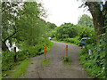
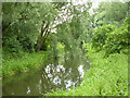
6
Leybourne Lakes Country Park
Bracket fungus. The park, which opened in 2004, was created from disused gravel pits that have been flooded and landscaped to make fishing and wildlife lakes. The nearby housing development of 'The Lakes in Leybourne' by Berkeley Homes was built beside one of the disused gravel pits that had been turned into man-made lakes and the impact of the development was offset by the creation of the country park and handed over to Tonbridge and Malling Borough Council in 2004 and, since November 2021, it has been managed by Tonbridge & Malling Leisure Trust. They are the current owners and maintain the lakes and paths.
Image: © pam fray
Taken: 10 Sep 2024
0.12 miles
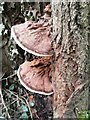
8
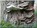
Leybourne Lakes Country Park
Bracket fungus on dead tree. The park, which opened in 2004, was created from disused gravel pits that have been flooded and landscaped to make fishing and wildlife lakes. The nearby housing development of 'The Lakes in Leybourne' by Berkeley Homes was built beside one of the disused gravel pits that had been turned into man-made lakes and the impact of the development was offset by the creation of the country park and handed over to Tonbridge and Malling Borough Council in 2004 and, since November 2021, it has been managed by Tonbridge & Malling Leisure Trust. They are the current owners and maintain the lakes and paths.
Image: © pam fray
Taken: 10 Sep 2024
0.14 miles
9
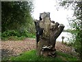
Leybourne Lakes Country Park
Dead tree by Larky 2 Lake. The park, which opened in 2004, was created from disused gravel pits that have been flooded and landscaped to make fishing and wildlife lakes. The nearby housing development of 'The Lakes in Leybourne' by Berkeley Homes was built beside one of the disused gravel pits that had been turned into man-made lakes and the impact of the development was offset by the creation of the country park and handed over to Tonbridge and Malling Borough Council in 2004 and, since November 2021, it has been managed by Tonbridge & Malling Leisure Trust. They are the current owners and maintain the lakes and paths.
Image: © pam fray
Taken: 10 Sep 2024
0.14 miles