IMAGES TAKEN NEAR TO
Dryland Road, SNODLAND, ME6 5HE
Introduction
This page details the photographs taken nearby to Dryland Road, ME6 5HE by members of the Geograph project.
The Geograph project started in 2005 with the aim of publishing, organising and preserving representative images for every square kilometre of Great Britain, Ireland and the Isle of Man.

There are currently over 7.5m images from over14,400 individuals and you can help contribute to the project by visiting https://www.geograph.org.uk
Image Map (Loading...)


Getting Data...Please wait
Leaflet Map data © OpenStreetMap
Images are licensed for reuse under creativecommons.org/licenses/by-sa/2.0
Notes
- Clicking on the map will re-center to the selected point.
- The higher the marker number, the further away the image location is from the centre of the postcode.
Image Listing (42 Images Found)
Images are licensed for reuse under creativecommons.org/licenses/by-sa/2.0
Image
Details
Distance
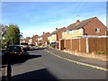
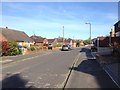
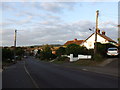
6
Snodland Housing Estate
Although Snodland is mentioned in the Domesday Book, much development has gone on in the last 40 years turning the town into largely a commuter village, due to its proximity to the M20 and M2 motorways.
Image: © Hywel Williams
Taken: 18 Jun 2005
0.11 miles

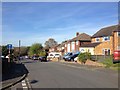
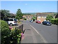
10
Rookery Hill, Birling Road, Snodland
Image: © Chris Whippet
Taken: 19 Aug 2013
0.14 miles