IMAGES TAKEN NEAR TO
Edwards Close, SNODLAND, ME6 5GD
Introduction
This page details the photographs taken nearby to Edwards Close, ME6 5GD by members of the Geograph project.
The Geograph project started in 2005 with the aim of publishing, organising and preserving representative images for every square kilometre of Great Britain, Ireland and the Isle of Man.

There are currently over 7.5m images from over14,400 individuals and you can help contribute to the project by visiting https://www.geograph.org.uk
Image Map
Images are licensed for reuse under creativecommons.org/licenses/by-sa/2.0
Notes
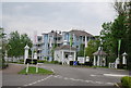
- Clicking on the map will re-center to the selected point.
- The higher the marker number, the further away the image location is from the centre of the postcode.
Image Listing (44 Images Found)
Images are licensed for reuse under creativecommons.org/licenses/by-sa/2.0
Image
Details
Distance
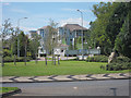
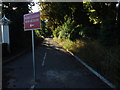
2
Manley Boulevard, Holborough Lakes near Snodland
Image: © Chris Whippet
Taken: 31 Aug 2009
0.03 miles
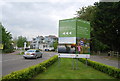
4
Manley Boulevard
Looking across a roundabout on the A228 Snodland Bypass.
Image: © Oast House Archive
Taken: 24 Jul 2011
0.05 miles
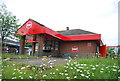
5
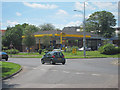
Jet filling station
By roundabout on Snodland Bypass.
Image: © Oast House Archive
Taken: 24 Jul 2011
0.07 miles
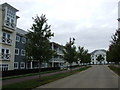
9
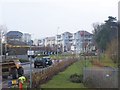
New Houses on Holborough Roundabout
On Ladds Lane, leading away from A228 Snodland By-Pass.
New England style houses being built by Berkeley Homes.
For more details see http://www.Holborough.co.uk
Image: © David Anstiss
Taken: 12 Dec 2008
0.08 miles